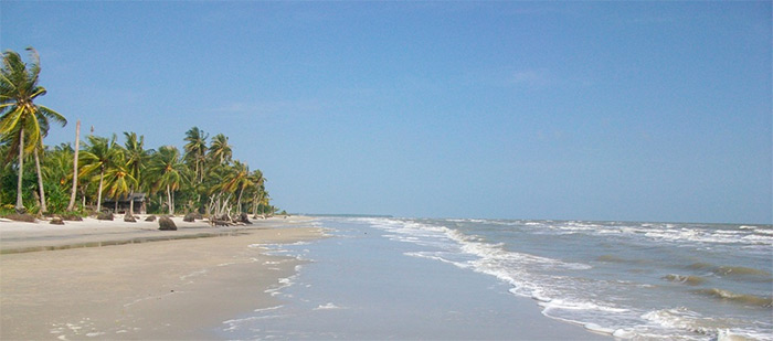
Rupat beach in Rupat Island
Pantai Pesona Rupat is the name given to the island of North Rupat, Bengkalis, Riau. Rupat Island elongated and deal directly with the Strait of Malacca in Malaysia.
Rupat beach was once has a name that varies according to the name of the residents of each village, namely Pantai Tanjung Lapin, Pantai Tanjung Rhu and Pantai Tanjung Punak. This beach extends from east to west and dealing directly with Tanjung Rusa in Port Dickson, Malaysia. The beach area which has a group of mineral soil with levels of youth development, either with or without the characteristic hidromorfik traits.
We can see the passing ships, both national and internationl at his northern Beach. it is supported by state of the sea that has a depth of 10-30 meters.
Because of the unavailability of public transportation to this islanf, it finally covered by a society that provides motorcycle taxi to drive the tourist to the location. The transportation to Rupat is actually can be taken from speedboat, Roro Ship or Pompong ship from some of ports.
Rupat island has an area of 1524.84 km2, which is actually a combination of four islands that seemed to coalesce into an island. The island is onsists of two sub-districts; Rupat sub-district and North Rupat. Rupat sub-district located in the south Rupat and it has 10 villages, namely, Makeruh, Batu Panjang, Hutan Panjang, Pangkalan nyirih, Pergam, Sei Cingam, Sukarjo Mesim, Tanjung Kapal, Terkul and Teluk Lecah.
The condition of Rupat beach is similar to Sanur Beach in Bali, with flat sandy beach and additional stunning view from Port Dickson in Malaysia at night

Moving Bats and Islands in Zamrud Lake
Luxurious and quiet. Perhaps this is one of the appropriate nicknames for the calm and spacious beauty of Zamrud Lake. The lake which located in conservation area is located in Siak Sri Indrapura Regency, Riau province. Besides having a large surface, this lake also has islands. There are large and small islands. Uniquely, these islands can move. This island is marshland floating above the lake. Big and deep, of course. You can not imagine how deep this lake is. Not only that. On this big island also live thousands of…
Kerumutan Reserve Forest, Riau
This wildlife reserve forest is spread in an area of ??1,332,169 ha and it inhabited by many species of flora and fauna that typical of lowland forest. Its area of mangrove trees decorated corridor through the Kampar River, that made ??it so special among other forests which spread across the island of Sumatra. Kerumutan reserve forest is a conservation area that located in Kerumutan sub-district and spreading across two districts namely Pelalawan and Indragiri Hulu, Riau Province. The forest boundary is the River of Indragiri, Kampar River, the East Coast…
Rimbo Tarantang, Riau
Rimbo Terantang tourism forest is located in Padang Lawas village. This tourism is having marvelous nature tourism between the genuine forest and it has exotic flora. This tourism object is officially becomes the research area for nature phenomenon for both flora and fauna. This type of tourism for this forest is adventurous tourism; the visitors who come to this place are those who seek for adventure need while enjoy the fresh atmosphere, chilling situation and great sightseeing. www.indonesia-tourism.com
Merbau Island – Riau
Merbau Island Merbau is an Island and a district in the Meranti Islands regency, Riau, Indonesia. The city district is Renak Rungun. Meranti Islands Regency is a result of the expansion area Merbau District, formed on January 26, 2011. Where the Pulau Merbau District is covering the entire island of Pulau Merbau, while Merbau subdictrict covers the entire island of Padang. The island has bordered with Malaka strait in north, west Tebing Tinggi sub district in south, Merbau sub district in west, west Rangsang in east. www.indonesia-tourism.com